Maps identifying the opportunities for a range of Natural Flood Management techniques are now available for the Kent catchment on our website.
The Rivers Trust commission JBA and Lancaster University to model the potential impact of Natural Flood Management (NFM) on peak flows. This helps to identify opportunities and suggest which sub-catchments may be most suitable for NFM interventions. Modelling was undertaken for the following options:
- Woodland and Scrub Planting
- Run-off Attenuation Features
- Soil Improvement
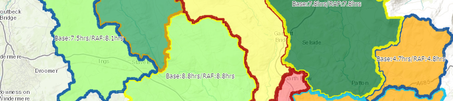
The maps also identify the time to peak for each sub-catchment and the potential reduction in peak time which can be achieved by implementing all the opportunities identified, which is important when considering the de-synchronization of peak flows. This information helps inform planning and delivery of techniques to reduce flood risk to local communities.
Please take a look at the maps for more information.
Further information on the work to reduce flood risk across Cumbria can be found on the Cumbria Strategic Floods Partnership Website.